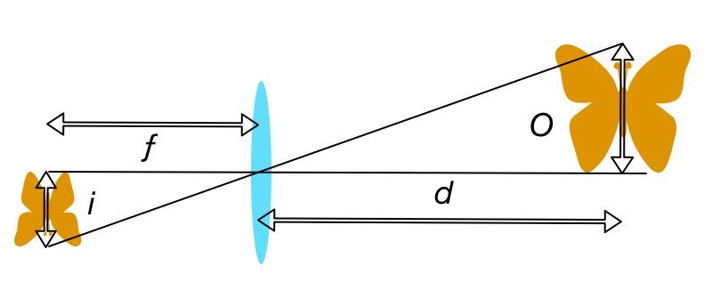
For non-wide-angle lenses, and subject distances much larger than the lens's focal length (your use-case certainly applies), the imaging system obeys the following basic equality:
(distance to object, d) / (size of object, O) = (focal length, ƒ) / (size of image, i)
This follows from the relationship of similar triangles as shown below:

Thus, ƒ = d * i / O. In your case, you want your images to have roughly the same spatial resolution as Google's aerial photos, which have about 6" (15 cm) resolution per pixel. So O = 150 mm. Since that's per-pixel, i is just the pixel size of the sensor you're using. You can look up the actual pixel pitch for your particular sensor, but knowing that a full frame sensor is 36 mm wide, you can just calculate i = 36 mm / (# horizontal pixels, pw).
Putting it together, ƒ = d * 36mm / (pw * O), where d is just your altitude. For example, the Sony a7r II sensor has 7952 horizontal pixels, so at 1,000 m altitude you'd need a lens with focal length ƒ = 1000 m * 36 mm / (7952 * .15 m) = 30 mm.
Lower altitude would give you higher resolution. However, if you wanted to reduce the focal length to maintain a similar spatial resolution, for lenses with a focal length below around 30 mm (on full frame cameras), the lens is considered wide angle. Around 24 mm and lower, depending on the lens, it might not obey the pinhole projection formula (which the ratio of similar triangles describes above). Instead of an equirectangular projection for normal and long focal length lenses, the lens might have projection distortion farther away from the image center. Again, depending on the specific lens you choose.


